
Aerial Drone
Data Gathering
Hover Visions Aerial Data
Gathering Services
Land set for Pre-Construction as well as land used for aggregate, sand and coal will benefit from the use of current and up-to-date aerial data gathering.
Aerial Data Collection and Gathering services makes it possible to access areas that may pose health, safety and environmental risks in a fast and safe way.
- inspection of areas difficult to access
- preventive maintenance planning and optimised production
- access to areas that pose health, safety and environmental risk to humans
- quick on-site deployment of the drone inspection system
- authorised and qualified UAV-inspection personnel
- reduced downtime.
Hover Visions drone solution
Hover Visions is a complete end-to-end drone data collection provider. We gather, analyze, and distribute aerial data to your business quickly and more cost effectively than ever before.
Land and Development Project
Aerial Data Gathering
From Pre-Construction work through the finished and completed project, Hover Visions provides the best aerial data collection process, aerial photography and video support for your operational needs. Data collection, photos and/or video of your project are taken on a set scheduled in an effort to assist the client in the monitoring of a project.
Mapping processes can also assist Project Managers in project oversite during construction phases.

Construction Project
Broken Arrow, Oklahoma

Multi-Story Office Complex Construction
Oklahoma City, Oklahoma
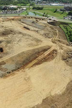
Pit and Quarry
Aerial Data
Aggregate, Sand, Coal and other like kind producers will realize a great benefit from actionable aerial data collected on their site. After processing photos from an aerial scan, Hover Visions can provide stockpile volume calculations, slope grading calculations, area measurements, 3D models, Contour models and more.
Resulting calculations are within 1% to 2% of land-based surveys, is performed in a safer manner, can many times be performed without coming onto the property, completed 40% to 50% faster than traditional methods and is 30% to 40% cheaper.

Rock Quarry Aerial Photography
Oklahoma

3D Rendering of Rock Quarry
Oklahoma